
Major Accomplishments
Geo-environmental appraisal and disaster monitoring using remote sensing techniques.
Ionospheric Radar Remote Sensing/SAR interaction with the ionosphere.
Geo-environmental appraisal and disaster monitoring
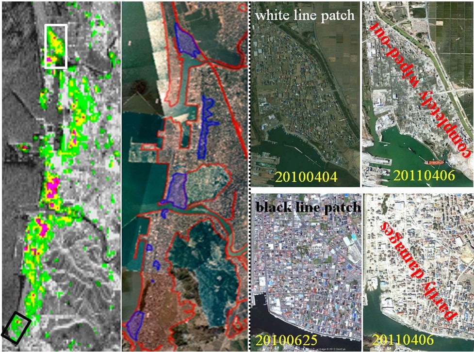
Geo-environmental appraisal through Geo-informatics approaches with a special emphasis of statistical modeling in landslide hazard zones and soil erosion, have been investigated. The G4U based new method is developed to effectively utilize the very-high-resolution fully polarimetric synthetic aperture radar (FULL-POL-SAR) data for near-real-time earthquake and/or tsunami damages assessment in urban areas. This G4U based newly developed method also holds for other types of disaster assessments application and his representative papers published are as follows:
G. Singh “Geo-environmental appraisal through Geoinformatics in the part of Mizoram with a special emphasis of spatial statistical modeling in landslide hazard zonation”, Master of Technology Thesis, Birla Institute of Technology Mesra, Ranchi, July 2005.
A.C. Pandey, M.S. Nathawat, G. Singh, “Evaluating Geo-aspects implications on land sliding in Himalayan Terrain in a part of Aizwal district, Mizoram State using remote sensing and GIS”. International Archives of the Photogrammetry, Remote Sensing and Spatial Information Sciences, Vol. 34, Part XXX.
Ramavtar, C. K. Singh, G. Singh, R. L. Verma, S. Mukherjee, H. Sawada, “Landslide susceptibility zonation study using remote sensing and GIS technology in the Ken-Betwa River link area, India”, Bulletin of Engineering Geology and the Environment , vol. 70, no. 4, pp. 595-606, Nov. 2011.
G. Singh, Y. Yamaguchi, W.-M. Boerner and S.-E. Park, “Monitoring of the March 11, 2011, Off-Tohoku 9.0 earthquake with super-tsunami disaster by implementing fully polarimetric high resolution POLSAR techniques”, Proc. IEEE, vol. 101, no.3, pp. 831-846, March 2013. [PDF]
Snow parameters estimation and glacier monitoring
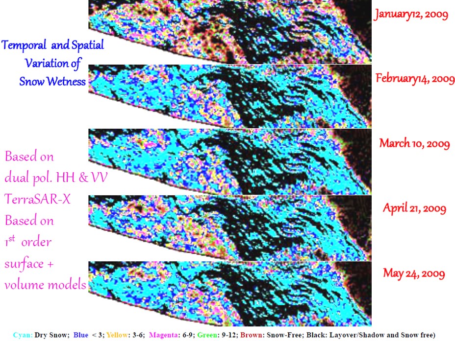
The research on snow studies was to fill the gap in the knowledge due to the absence of suitable methodologies for retrieving snow parameters in the Himalayas, by developing techniques for detection and monitoring of snow cover related processes, based on multi-temporal, multi-polarization satellite radar remote sensing data. Novel inversion algorithms are also developed based on SAR polarimetry for estimating snowpack characteristics accurately like snow wetness, density, grain size, snow water equivalent etc. An innovative wet snow cover mapping technique based on polarization fraction and third eigenvalue of coherency or covariance matrix, known as radar snow index, has also been invented. A novel Generalized Singh-Cloude Hybrid Three Component decomposition (referred as GS3H) method is established by inclusion of generalized spheroidal shape of snow grain in volume scattering model for the estimation of snowpack density using fully polarimetric SAR (POLSAR) data. Near real-time field observations on snow wetness, density, depth, temperature and depth have been recorded and utilized for validating the results estimated on the basis of SAR data analysis. A first ever methodology for snowpack depth estimation using space-borne bistatic PolInSAR coherence information over Himalayan snow-covered region is established. Bistatic polarimetric radar scattering model in snow media is established, which is implemented for development of a novel scattering parameter inversion algorithm for snowpack density retrieval using bistatic fully polarimetric data set. Snow water equivalent (SWE) inversion algorithm is also established for bistatic polarimetric SAR.
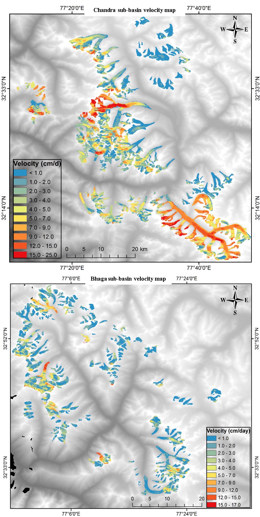
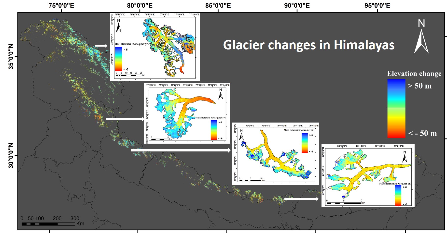
Moreover, optical and radar remote sensing data are being used for monitoring the retreat of glaciers and mapping of glaciers. Glacier remote sensing based techniques evolved to estimate mass balance of different glaciers. For this purpose, snow accumulation area ratio and equilibrium line altitude based methods were extracted. DEM derived from stereo optical data, SAR interferometry techniques and also from Tandem-X were exploited to evaluate mass balance of various glaciers involving limited field based mass balance measurement values. Differential InSAR techniques are now concurrently being assessed to estimate the glacier movement. Intensity tracking techniques have been successfully used to understand the glacier movement. Recent break through contributions to Himalayan Glaciology science are (1). Basin wise DInSAR based glacier velocity estimation, (2) anomalous glacier dynamics, and (3) disintegrating behaviour of glaciers. A recent research also involves assessing the mass budget for Pan-Himalaya using freely disseminated global Digital elevation models (DEMs), which is the first demonstration of the potential of bistatic DEMs over this region.
Categorization of the glaciated terrain of Indian Himalaya using compact polarimetric and fully polarimetric mode SAR has also been done. Moreover, a new fully polarimetric SAR processing technique has been developed by combining supervised classification and scattering power decomposition methods for improving the rugged terrain glacier classification techniques – a highly challenging problem of further research and his representative papers published are as follows:
G. Singh , V. Kumar, G. Venkataraman, Y.S. Rao, and Snehmani, “Snow porosity estimation using advanced synthetic aperture radar single look complex data analysis and its effects on backscattering coefficient”, Journal of Applied Remote Sensing, vol. 1, no. 1, July 2007, DOI: 10.1117/1.2771253 (published online).
G. Singh and G. Venkatraman, “Snow wetness mapping using advanced synthetic aperture radar data”, Journal of Applied Remote Sensing, vol. 1, no 1, July 2007, DOI:10.1117/1.2768622 (published online ).
G. Singh and G. Venkataraman, “Snow permittivity retrieval inversion algorithm for estimating snow wetness”, Geocarto Int., vol. 25, no. 3, pp.187- 212, June 2010. (PDF)
Snehmani, G. Venkataraman, A K Nigam and G. Singh , “Development of inversion algorithm for dry snow density estimation and its application with ENVISAT-ASAR dual co-polarization data”, Geocarto Int., vol. 25, no. 8, pp. 597 - 616, Dec. 2010. (PDF)
G. Singh, “SAR polarimetry techniques for snow parameters estimation,” Ph.D. dissertation, Centre Stud. Resour. Eng. (CSRE), Indian Inst. Technology Bombay, India, Sep. 2010.
G. Venkataraman and G. Singh, “Radar application in snow, ice and glaciers”, V.P. Singh, P. Singh, U.K. Haritashya (Eds.), Encyclopedia of Snow, Ice and Glaciers, Springer, pp. 883-903, 2011, ISBN 978-90-481-2643-9.
G. Singh, Y. Yamaguchi and S.-E. Park, “Utilization of four-component scattering power decomposition method for glaciated terrain classification using fully polarimetric PALSAR data”, Geocarto Int., vol. 26, no. 5, pp., 377-389, Aug. 2011. (PDF)
G. Singh, Y. Yamaguchi and S.-E. Park, “Evaluation of modified four-component scattering power decomposition method over highly rugged glaciated terrain”, Geocarto Int., vol. 27, no. 2, pp. 139-151, Apr. 2012.
G. Singh, G. Venkataraman, Y. Yamaguchi and S.-E. Park, "Capability assessment of fully polarimetric ALOS PALSAR data to discriminate wet snow from other targets”, IEEE Trans. Geosci. Remote Sens., vol.52 no. 2, pp. 1177-1196, Feb. 2014. DOI: 10.1109/TGRS.2013.2248369. (PDF)
G. Singh, Y. Yamaguchi, and S.-E. Park, W.-M. Boerner, Y. Cui, and G. Venkataraman, “Categorization of the glaciated terrain of Indian Himalaya using CP and FP mode SAR”, IEEE J. Selected Topic in Appl. Remote Sens., vol.7, no. 3, pp. 872-880, Mar. 2014. DOI: 10.1109/JSTARS.2013.2266354. (PDF)
S.-E. Park, Y. Yamaguchi, G. Singh , S. Yamaguchi and A. C. Whitaker, “Polarimetric SAR response of snow covered area observed by multi-temporal ALOS-PALSAR fully-polarimetric mode”, IEEE Trans. Geosci. Remote Sens., vol.52 no. 1, pp. 329-340, Jan.2014. DOI:10.1109/TGRS.2013.2240000. (PDF)
G. Singh, Y. Yamaguchi and S.E. Park, “Evaluation of modified four-component scattering power decomposition method over highly rugged glaciated terrain”, Geocarto International, vol. 27, no. 2, pp. 139-151, 2012. (PDF)
Surendar M., A. Bhattacharya, G. Singh, Yand G. Venkataraman “Estimation of snow density using full-polarimetric synthetic aperture radar (SAR) data” Physics and Chemistry of the Earth, vol. 83-84, pp. 156-165, 2015.
Surendar M., A. Bhattacharya, G. Singh, Y. Yamaguchi , and G. Venkataraman, “Development of a snow wetness inversion algorithm using polarimetric scattering power decomposition method” Int. J. Appl. Earth Observ. Geoinfo., vol.42 , pp. 65-75, Oct. 2016
P. Pandey, M. Surendar, A. Bhattacharya, A.L. Ramanathan, G. Singh<, G. Venkataraman, "Qualitative and quantitative assessment of TanDEM-X DEM over Western Himalayan glaciated terrain", Geocarto International, Vol. 32 , no. 4, pp. 442-454, 2017
M. Surendar, A. Bhattacharya, G. Singh, Y.Yamaguchi, "Estimation of snow surface dielectric constant from polarimetric SAR data", IEEE J. selected topic in Appl. Remote Sens, vol. 10, no.1, pp. 211 - 218, Jan 2017.
G. Singh, A. Verma, S. Kumar, Snehmani, A. Ganju, Y. Yamaguchi, A.V. Kulkarni, "Snowpack density retrieval using fully polarimetric TerraSAR-X data in the Himalayas", IEEE Trans. Geosci. Remote Sens., vol. 55, no. 11, pp. 6320 – 6329, Nov. 2017
Surface parameters retrieval over India
In this research project, the potential of multi polarization ALOS-PALSAR data for the retrieval surface parameters (without vegetation cover surface and under vegetation cover condition) was investigated for various sites of India. The main surface parameters viz. soil moisture and roughness were retrieved with the help of the ALOS-PALSAR data by proposing inversion models for second order statistics of FULL-POL-SAR measurements and his representative papers published are as follows:
G. Singh, “ALOS-PALSAR data applications for surface parameters retrieval over India”, PI JAXA-599 report, Japan Aerospace Exploration Agency (JAXA), Japan, 2013.
Radar polarimetry
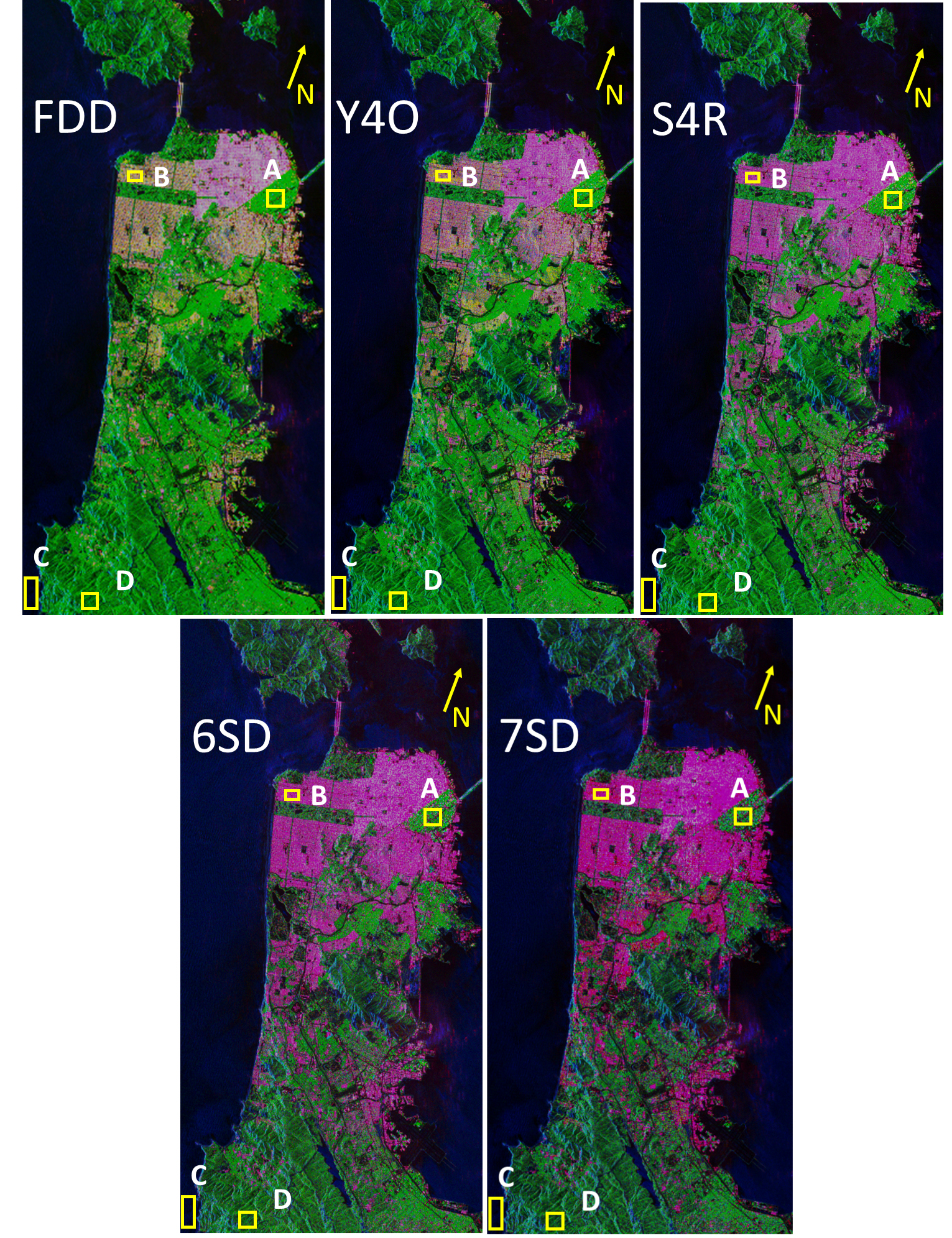
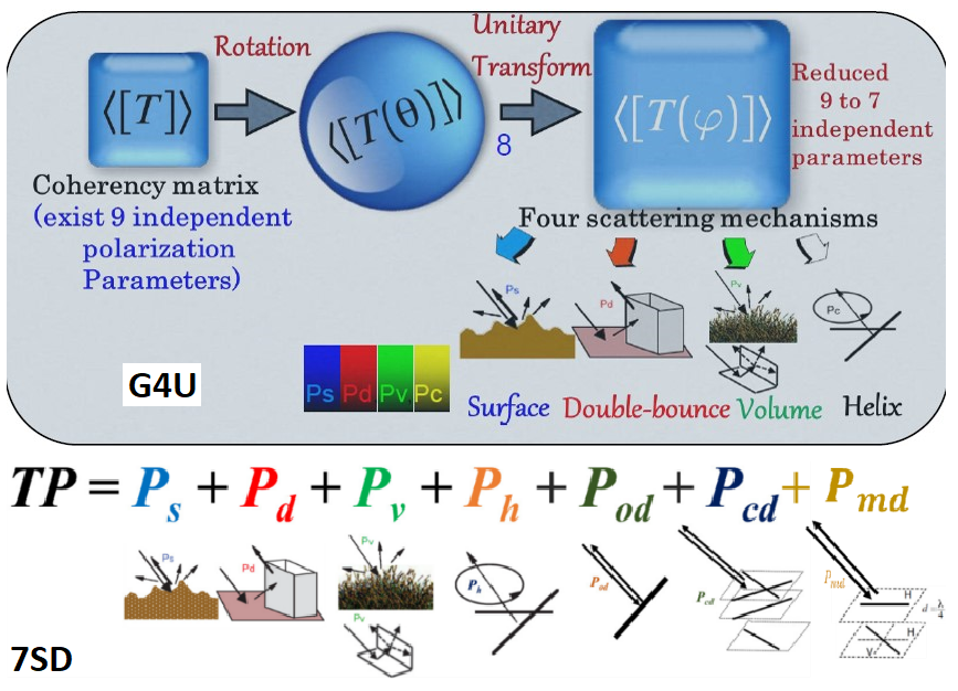
This research attempts to bridge the intellectual gap at the radar polarimetry method terminus, where radar polarimetry theories/methods developments traditionally ends, --- and the Earth surface parameters monitoring traditionally begins. More specifically, a new fully polarimetric SAR processing technique has been invented by combining the complex Wishart distribution and scattering power decomposition method for improving the rugged terrain classification. The research also focuses on the development of a new volume scattering model that accounts for the cross-polarized (HV) component caused by cloud of dipoles, dihedral structures and spheroidal shape particles. The newly developed model is employed in the four-component scattering power decomposition, leading to an improvement in urban areas extraction. An improved hybrid decomposition scheme is also developed for improved interpretation of existing decomposition approaches. The result was published in the scientific journal IEEE Geosci. Remote Sens. Lett. vol.10/1, as the front cover art for that issue. (PDF) . The classification between vegetation and the buildings becomes inconclusive when based on HV components caused by dipole scattering. Therefore, it was proposed to use an extended volume scattering model suited for oriented urban buildings (i.e., oriented dihedral model) to mitigate the overestimated volume scattering problem. This proposed method resolves the discrimination ambiguity of oriented dihedral objects from vegetation, by implementing the extended volume scattering model and the concept of rotation about line of sight. Furthermore, the utilization of 100% polarimetric relative phase information in the model-based decomposition was one of the main issues in Radar Polarimetry research for the past two decades. Finally, the general four-component scattering power decomposition with unitary transformation of coherency matrix (G4U) (PDF) was developed to incorporate 100% polarimetric relative phase information in the model-based decomposition. Two generalized fully polarimetric volume and surface parameters are also developed and are useful for extracting a dielectric constant retrieval inversion algorithm. CP versus FP comparison based on excellent fully polarimetric PALSAR images has been done. Although we used very excellent data but results of CP are poorer as compared to the FP results. Recently the Six-component scattering power decomposition (6SD) is introduced. The 6SD method extracts surface scattering power, double-bounce scattering power, volume scattering power from dipole and/or oriented dihedral, helix scattering power, oriented dipole scattering power and compound dipole scattering from the total power received by radar after the interaction with target. An establishment of 6SD also includes the discovery of two new radar scattering nature, which are modelled to account for the all elements (both real and imaginary) of coherency matrix. The result was presented in the highly reputed scientific symposium IEEE International Geosciences and Remote Sensing Symposium during July 23–28, 2017 at Fort Worth, Texas, USA, and selected as the front and back cover art for that technical program guide book. With detailed analysis the manuscript has been submitted to IEEE Trans. Geosci. Remote Sens. A new model-based scattering power decomposiion method called as the seven-component scatter power decomposition (7SD) has been developed. The decomposition comes with an elaborative explaination for the new scattering model for Real{T23} and his representative papers published are as follows:
G. Singh, Y. Yamaguchi and S.-E. Park, “Utilization of four-component scattering power decomposition method for glaciated terrain classification using fully polarimetric PALSAR data”, Geocarto Int., vol. 26, no. 5, pp., 377-389, Aug. 2011. (PDF)
G. Singh, Y. Yamaguchi and S.E. Park, “General four-component scattering power decomposition using unitary transformation”, IEEE Trans. Geosci. Remote Sens., vol. 51, no. 5, pp. 3014-3022, May 2013. (PDF)
G. Singh, Y. Yamaguchi, S.-E. Park, Y. Cui and H. Kobayashi, “Hybrid Freeman/eigenvalue model with extended volume scattering model”, IEEE Geosci. Remote Sens. Lett, vol. 10, no. 1, pp. 81-85, 2013. (PDF)
A. Sato, Y. Yamaguchi, G. Singh and S.E. Park, “Four-component scattering power decomposition with extended volume scattering model”, IEEE Geosci. Remote Sens. Lett, vol. 9, no. 2, pp. 166-170, 2012. (PDF)
G. Singh, S.-E. Park, Y. Yamaguchi, W.-M. Boerner and G. Venkataraman, "Full-POL-SAR decomposition over wet snow", IGRASS 2012, Munich, Germany, July 22-27, 2012.
G. Singh, “Development of general radar polarimetry methods for fully polarimetric synthetic aperture radar data utilization to monitor the Earth”, Dr. Eng. dissertation, Electrical and Information Engineering, Niigata University, March 2013. (PDF)
G. Singh, Y. Yamaguchi, and S.-E. Park, W.-M. Boerner, Y. Cui, and G. Venkataraman, “Categorization of the glaciated terrain of Indian Himalaya using CP and FP mode SAR”, IEEE J. Selected Topic in Appl. Remote Sens., vol.7, no. 3, pp. 872-880, Mar. 2014. DOI: 10.1109/JSTARS.2013.2266354. (PDF)
G. Singh, R. Malik, S. Mohanty, V. S. Rathore, K. Yamada, M. Umemura and Y. Yamaguchi, “Seven component scattering power decomposition of coherency matrix”, IEEE Trans. Geosci. Remote Sens. [in press].
3-D SAR Tomography

The research is aimed at development of techniques for space-borne SAR tomography and its application for forest 3-D structure mapping. Two major limiting factors for space-borne SAR tomography are temporal decorrelation and uneven baseline distribution. To mitigate temporal decorrelation effects, a novel single-pass TomoSAR processing technique has been invented and applied on space-borne TanDEM-X SAR data (X-band) over Indian tropical forest. This provides the globally first ever space-borne SAR tomograms over a tropical forest, which are demonstrated for first time at DLR PI meet in 2016. A robust tomogram phase calibration approach is also developed utilizing polarimetric scattering diversity and relative phase center heights. This results in well-focused tomograms over multi-species Indian tropical forest. Another research gap identified is the lack of 3-D scattering information retrieval algorithms. To exploit the 3-D information content, an advanced Python based multi-pass interferometric SAR processor was developed. This processor is applied on fully-polarimetric TanDEM-X data to retrieve the vertical forest dynamic scattering information. The potential of TomoSAR for retrieval of forest bio-physical parameters, under-canopy scatterer detection and species identification is explored. This investigation contributed to the overall radar remote sensing domain by development of first space-borne SAR tomograms over an Indian tropical forest, robust phase calibration strategies and development of space-borne SAR data 3-D scattering information retrieval algorithms.
A new model-based scattering power decomposiion method called as the seven-component scatter power decomposition (7SD). The decomposition comes with an elaborative explaination for the new scattering model for Real{T23}
His representative papers published are as follows:
G. Singh. U. Khati, and L. Ferro-Famil, “Forest parameter estimation over indian forests using TanDEM-X observations,” presented in TerraSAR-X/TanDEM-X Sceince Team Meeting 2016, October 17-20, 2016 at DLR Oberpfaffenhofen, Germany.
G. Singh. U. Khati, and L. Ferro-Famil, “Forest parameter estimation over indian forests using TanDEM-X observations,” presented in TerraSAR-X/TanDEM-X Sceince Team Meeting 2016, October 17-20, 2016 at DLR Oberpfaffenhofen, Germany.
U. Khati, M. Lavalle, G. Singh, “Single-pass Spaceborne Tomography of Multi-Species Indian Tropical Forests”, Remote Sens. Environ., 2019 ( in press)
Bio-physical parameters
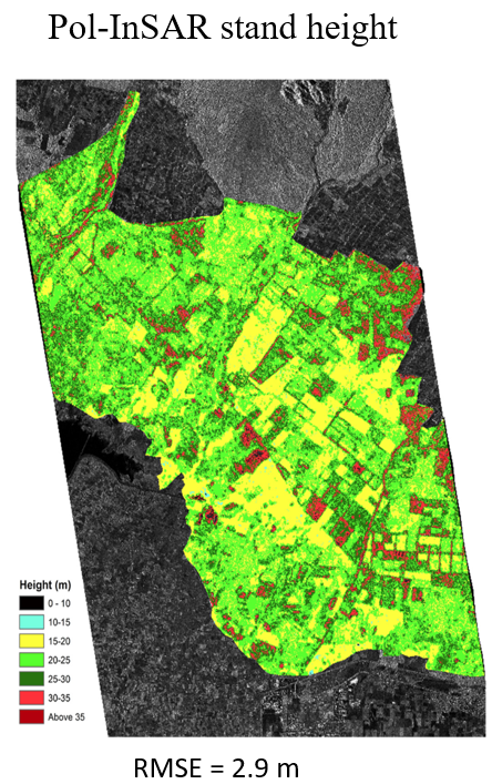
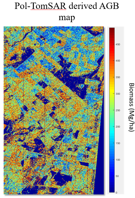
This research work is to fill the gap of non-availability of high resolution forest bio-physical maps/information over India. This is mainly due to absence of airborne data and relatively under-explored potential of spaceborne SAR data. Two major forest bio-physical parameters – forest height and biomass, providing indication of forest health are identified. Multi-frequency (L-, C- and X-band) space-borne PolInSAR data are acquired over a tropical forest in North India. A modified PolInSAR inversion algorithm, which combines the interferometric and polarimetric information is investigated for generating a spatial distribution of forest height. The result provides comparative assessment of space-borne SAR data for forest height retrieval in India. Further, insight into effects of temporal decorrelation led to development of a simple temporal decorrelation magnitude estimation technique. This provides decorrelation magnitude over different time gaps and it is concluded that zero-temporal gap TanDEM-X acquisitions and ALOS-2/PALSAR-2 acquisitions provide the most reliable forest bio-physical parameters. To explore this further, multiple TanDEM-X acquisitions in varied baselines are acquired over three Indian forests (comprising managed, deciduous and evergreen forests). The analysis provides a holistic analysis of SAR techniques over multi-type tropical forests. Further a comprehensive study is carried out for development and comparison of SAR remote sensing techniques for accurate forest biomass inversion. Contemporary techniques still have errors up to 30% of mean biomass. The PolSAR (radar backscatter), PolInSAR (height) and TomoSAR (3-D structure) inversion algorithms are developed for retrieving forest biomass. Extensive analysis is carried out and it is shown that a combination of ALOS-2/PALSAR-2 backscatter and TanDEM-X PolInSAR height lead to accurate extraction of spatial variation of forest biomass. This model was independently validated at two distinct forests in India and potential for cross-validation was explored. Further, TanDEM-X tomogram based layered backscatter is inverted for biomass mapping. The research also highlights the potential of X-band tomograms for low-biomass region mapping where the higher wavelength data of P-band and L-band shows lower sensitivity.
Scattering pattern changes over tropical forests due to phenology change and deforestation are analyzed. Over deciduous forests in India, the leaf-fall affects X-band scattering and leads to anomaly in PolInSAR height estimates. The nature of leaf-fall mechanisms in tropical dediduous and boreal forests differ which is highlighted in this study. This trend is analyzed through scattering mechanism change monitoring and the study advises that leaf-on season is best to carry out PolInSAR based height inversion over India. Monitoring deforestation is important for forest monitoring. However, techniques for partial logging detection in tropics are still not mature where optical remote sensing is ineffective due to persistent cloud cover. The potential of dual-pol ALOS-2/PALSAR-2 data for partial logging detection is further analyzed using the entropy-alpha angle parameter analysis. The capability of fully polarimetric ALOS-PALSAR data has also been demonstrated for the characterization of the forests and deforestation in the part of Cambodia, to support climate change mitigation policies of Reducing Emission from Deforestation and Forest Disturbance; and these innovations are further pursued in detail. The challenges for vegetation information extraction using ALOS-PALSAR/PALSAR-2 measurements have been revealed in details.
His representative papers published are as follows:
Ramavtar, H. Sawada, W. Takeuchi, G. Singh, “Characterization of forests and deforestation in Cambodia using ALOS/PALSAR observation”, Geocarto International, vol. 27, no. 2, pp. 119-137, 2012.
Unmesh Khati, G. Singh, Laurent Ferro-Famil, “Analysis of seasonal effects on forest parameter estimation of Indian deciduous forest using TerraSAR-X PolInSAR acquisitions”, Remote Sens. Environ., vol. 199, pp. 265-276, Sept. 2017.
U. Khati, G. Singh and S. Kumar, “Potential of space-borne PolInSAR for forest canopy height estimation over India – A case study using fully polarimetric L-, C-, X-band SAR data”, IEEE J. selected topic in Appl. Remote Sens., vol. 11, no.7, pp 2406-2416, Jul 2018.
U. Khati, V. Kumar, D. Bandyopadhyay, M. Musthafa and G. Singh, “Identification of forest cutting in managed forest of Haldwani, India using ALOS-2/PALSAR-2 SAR data”, J. Environ. Manag. vol. 213, pp. 503-512, May 2018.
Ionospheric Radar Remote Sensing/SAR interaction with the ionosphere
A part of research done in the cryospheric radar remote sensing laboratory is in the field of ionospheric sciences, its dynamics and effects on polarimetric synthetic aperture radar (PolSAR) data. Work in this field concentrates on development of new measurement indices for quantifying the amount of scintillation affecting the SAR data. These indices can be predominantly used in conjunction with already existing scintillation measurement index from GPS. Alongside GNSS measurements, ionospheric scintillation-affected PolSAR data can also be used derived these scintillation parameters, thus becoming indicators of the scintillation strength. Interesting studies, such as determining the shape of irregularities causing scintillations can be determined using SAR. Depending upon their location on the Earth, these irregularities differ in shape, which is usually defined by a parameter called the anisotropy ratio. We have precisely identified these anisotropy ratios for irregularities occurring at low- and high-latitude regions.
Since scintillation-affected PolSAR data are damaged by striping artifacts, we have developed technique to correct these images for improved image interpretation.
His representative papers published are as follows:
S. Mohanty, C. Carrano, and G. Singh, 2019, ‘Effect of Anisotropy on Ionospheric Scintillations observed by SAR’, IEEE Transactions on Geoscience and Remote Sensing, doi: 10.1109/TGRS.2019.2909078 (Accepted for publication)
S. Mohanty, C. Carrano, and G. Singh, 2019, ‘Effect of Anisotropy on Ionospheric Scintillations observed by SAR’, IEEE Transactions on Geoscience and Remote Sensing, doi: 10.1109/TGRS.2019.2909078 (Accepted for publication)
S. Mohanty and G. Singh, C. Carrano , and S. Sripathi, “Ionospheric scintillation observation using space-borne Synthetic Aperture Radar (SAR) data”, Radio Science, vol. 53, no. 10, pp. 1187–1202, 2018.
S. Mohanty, C. Carrano, and G. Singh, 2018, ‘Synthetic Aperture Radar (SAR): An alternate for ionospheric scintillation studies’, 15th International Symposium on Equatorial Aeronomy (ISEA-15), Oct 22-26, PRL, Ahmedabad, India (Presented) [Best Young Scientist Paper Award]
S. Mohanty, and G. Singh, 2019, ‘Fully polarimetric synthetic aperture radar indices for scintillation observation’, URSI-AP RASC, March 9-15, New Delhi, India (Presented).
Toggle Menu