This is first indigenously built sun-synchronous polar orbiting satellite.
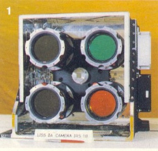
| Parameters | LISS-I | LISS-II |
| Focal Length | 166.2 | 324.4 |
| Field-of-view (deg) | 9.4 | 4.7+4.7 |
| Instantaneous field of view(IFOV) Microrad, | 80 | 40 |
| Detectors (CCDs) | 2048 elements CCD | 2048 elements CCD |
| Ground Resolution (m) | 72.5 | 36.25 |
| Spectral range (micro meter) | 0.45 - 0.86 | 0.45 - 0.86 |
| Number of Bands | 4 | 4 |
| Swath (Kms.) | 148 | 74x2 ( LISS-A and LISS-B) |
| Radiometric Resolution (grey levels) | 128 | 128 |
| Data rate (Mbps) | 5.2 | 10.4x2 |
| Weight (Kgs) | 38.5 | 80.8x2 |
| Power (Watts) | 34 | 34x2 |
* LISS -Linear Imaging Self-Scanning Sensor, CCD charge coupled devices.
* LISS-II contains two separate identical sensors LISS-A and LISS-B with a spatial resolution of 36.25 each.
* The 4 bands are:
B1 - 0.42-0.52 (blue)
B2 - 0.52-0.59 (green)
B3 - 0.62-0.68 (red)
B4 - 0.77-0.86 (near IR)
The bands are similar to the LANDSAT 1, 2, 3 and 4 bands.