
Spatial Decision Support System for rural Land Use Planning - SDSS/LUP
District/sub-district level planning, with emphasis on conservation management of the rural areas, have been stressed for many years in the successive National Development Plans. However, planning is meaningful only when the natural resources are seen in its spatial perspective, distributed over an area. Hence, it is imperative to generate and document a well organized spatial/non-spatial database of the district as a whole for macro-level planning and at block/watershed resolution for micro-level planning, which would in turn be useful in planning the conservation/watershed management programmes for sustainable development. In modern times, the information has been supplemented through Remote Sensing and GIS and has been used to reduce the information gaps. 1.2 Spatial Decision Support System for rural Land Use Planning (SDSS/LUP) In recent years in India, there has been a blossoming of participatory planning at very local levels fostered by NGO’s, but the established procedure for development planning remains top-down, by way of schemes to address specific problems and opportunities (Table1). These schemes are mandated and financed by the state or central government and implemented by sectoral institutions such as the Department of Agriculture. Table 1: Some of the specific items for attention drawn up by the 11th schedule, 73rd and 74th Constitutional Amendment Acts, 1992 Land improvement, implementation of land reforms, land consolidationSoil conservation Minor irrigation, water management, and watershed development Social forestry and farm forestry Roads, culverts, bridges, ferries, waterways Drinking water Fuel and fodder Rural electrification Adult and non-formal education Poverty alleviation programs Rural development planning is now being decentralized so that plans may take account of local conditions and needs. The key level of decentralized planning is the zilla (district). The mean area of the district is 6 810 km2 (and most are between 2000 and 20 000 km2) with a mean rural population of 1.8 million. Each district is divided into 15 – 20 talukas (blocks) and many panchayats (village clusters). Districts are now required to draw up and implement integrated development plans, and those districts that have independent tax-raising powers are in a position to initiate their own schemes to address local needs. This task is made the more difficult by the strictly sectoral structure of government activity and of formal information about natural resources, social and economic conditions and infrastructure. The Natural Resources Data Management System (NRDMS) is a multi-disciplinary programme of the Department of Science and Technology, Government of India, that is developing decision-support systems for decentralized planning using geographic information system (GIS) technology. Its immediate clients are planners and the professional staff of line ministries, in particular the departments of agriculture, forestry, rural development, irrigation and revenue at the district level (all line ministries are represented at district level). A DSS is a computer-based information system that assists a decision-maker at the moment of taking a decision. An SDSS is a DSS applied to spatial problems. Because of the spatial nature of the decisions, a GIS Geographical Information System must be the centerpiece of any SDSS. Planning in general is the process of allocating resources, including time, capital, and labor, in the face of limited resources, in the short, medium or long term, in order to produce maximum benefits to a defined group. Land use planning (LUP) is the activity of designating uses for different land areas (zoning), as well as specific interventions (e.g., infrastructure or local works, subsidies, material) that are necessary for carrying out those uses. Zoning may be proscriptive (also called normative), i.e. prohibiting certain uses in a zone, or prescriptive, i.e. advocating certain uses in a zone. In the context of rural India, planning mainly consists of the distribution of resources (infrastructure, subsidies, assistance) according to various ‘schemes’ that are mandated by Central or State governments, i.e. prescriptive planning. Planning may be participatory (bottom-up), where the people directly affected themselves make the plan. Or, planning may be executive (top-down), where decisions are taken by responsible agencies that supposedly represent the interests of society as a whole, and then take actions to implement or coordinate the plan. Spatial Decision Support System for rural Land Use Planning (SDSS/LUP) is an attempt towards a prescriptive and executive-level planning, i.e. where the decisions must be made on the use or allocation of resources in space by the responsible agencies.2.0 Conplan 2.1 Objectives The overall objective is to formulate spatial information on various resource parameters for conservation planning.
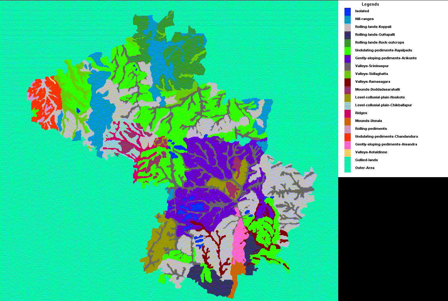
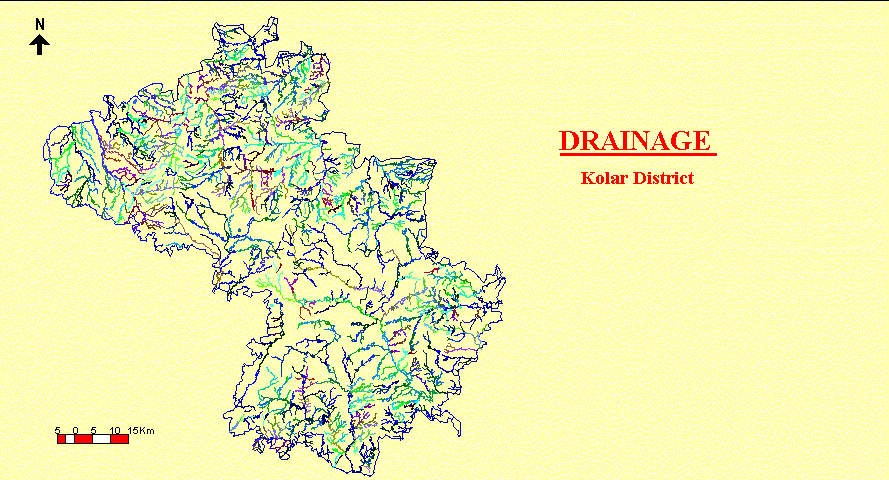
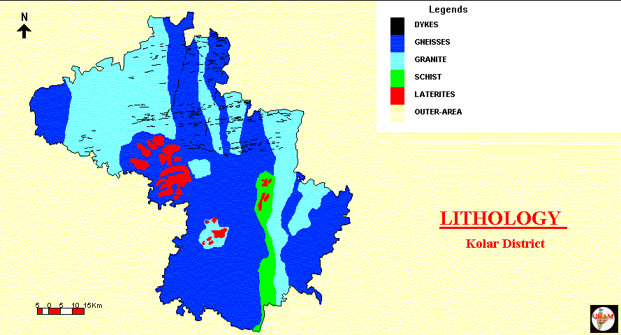
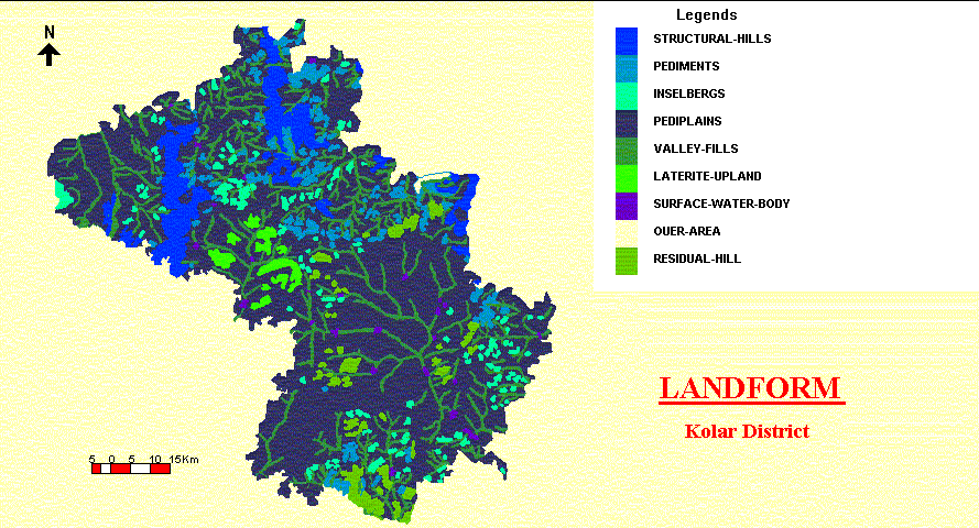
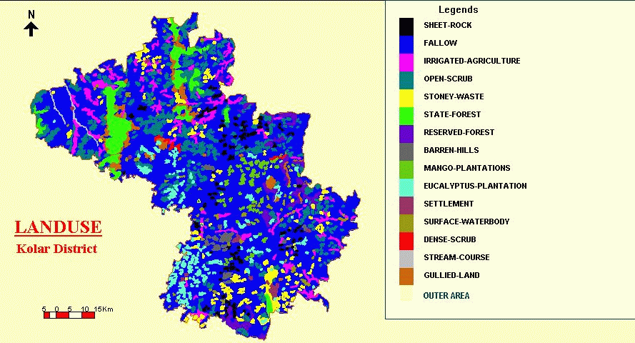
2.2 GIS-based spatial information at District-level The approach for generating district resource appraisal was tested in a rural-based and drought-prone Kolar District of district of the Mysore Plateau region. Generation of GIS thematic mapping was carried out at 1:250,000 scale using GRAM and GRAM++. 2.2.1 District Scenario The total geographical area of Kolar District is about 8223 km2. The district, bordering the Eastern Ghats in the north-east and the southern portions, belong to the Maidan (plain) group of districts in Karnataka State. The bedrock in the district is mostly the granitic in nature. The area has a local relief ranging from 1677 feet to 4749 feet. Kolar district is dotted with a number of hills and peaks of varying heights, particularly in north. The principal chain of mountains is the Nandidurga range. There are not perennial rivers in the district, most of them are being small. Three important rivers:Palar, North Pinakini and South Pinakini take their birth in the district and flow in different directions, receiving the drainage of the intermediate tracks of the district. The climate of the area is sub-tropical monsoonic. The district is situated half way between the eastern and western coasts, and comes under the influence of both the south west and north-east monsoons with an average annual rainfall of about 730 mm, out of which 69% is through south-west monsoon. The natural vegetation is scanty and consists of dry deciduous or thorny scrub types of forests (occupies are 10% of the district), shrubs and grasses. Land put to agricultural use forms roughly 1/3 of the total land area and dry cultivation occupies a pre-eminent place. Ragi is the most extensively grown crop in the district and is the staple foodgrain of bulk of the people. The soils of Kolar district are mainly divided into three types: red, clay loam and laterite. . The district has been experiencing drought for several years continuously in the past, and sometimes acute. There is no canal irrigation in the district and irrigation traditionally has been sustained by tanks which are distributed throughout the district. Many of these tanks are now completely dried up as a result of drought and silted up with reduction in storage capacity as well as preventing recharge of ground water. It is also gathered that the ground-water discharge through existing wells is very much over drawn resulting in lowering of ground-water table. Soil erosion in the district is an acute problem and may be attributed to poor soil conservation practices, scantily distributed vegetation cover and overall dry climate with an erratic monsoon rainfall. 2.2.2 Results achieved so far
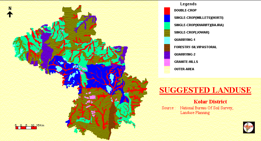
2.3 Conservation Planning Information Systems (CONPLAN) Bairasagara watershed, selected the NWDPRA scheme, was chosen for developing the information system for conservation planning. The watershed covers an area of approximately 100 sq. km., and contains about 60 villages, partly or completely, that falls in Chikballapur and Gudibanda talukas of Kolar district. The works completed in CONPLAN model, using GRAM, includes : A. Biophysical resources (1:50,0000)
B. Conservation Planning
3.0 Spatial Decision Support System for rural Land Use Planning (SDSS/LUP) The above mentioned project on CONPLAN was subsequently included in the UNDP/GOI (DST) joint programme " GIS based Technologies for Local Level Development Planning" (IND/95/002), under the Land Use Planning sector. The main objective of the project has been shifted from the development of a system-approach model ‘CONPLAN’ to the development of a decision-aid ‘Spatial Decision Support System for rural Land Use Planning -SDSS/LUP’, aimed at agencies that play at the local level. SDSS/LUP in the context of this project would be an automated system, applied to problems at the district or taluka level, that would assist a decision-maker at these levels to make zoning and intervention decisions. These planners are both the co-ordinating planners such as NRDMS District Centres, and those in relevant line agencies, among others Agriculture, Forestry, Rural Development, Revenue, Irrigation, Sericulture and other Natural Resources Management Community. Thus, some applications of the SDSS could be narrowly sectorial, while others could be broader, requiring an integrated approach. International experts have reviewed the SDSS/LUP approach at regular intervals. The international land evaluation specialists, Dr D.G Rossiter from the ITC-Netherlands and Dr David Dent from the Bureau of Rural Sciences-Australia, were consulted to conceptualise, to evaluate and to modify the model ‘SDSS/LUP’ in September 1998 for three weeks and in November 1999 for a week, respectively. 3.1 Conceptual Design (Framework) The concept of SDSS is to draw together the natural resources and land use data of sectoral agencies (topography, satellite imagery, census reports and thematic maps), process them to computer-compatible format, and build up a district database. The district database will be manned by an information specialist who can generate, on demand, a range of GIS products to assist planning and decision-making: analytical maps, statistical tables and input to models. Table 2 lists the thematic maps and attribute data that are being entered into the NRDMS database and linked by a geodetic reference framework. Table 2 : Thematic data held within the GIS Administrative boundaries Land
use/land cover/forestry/wildlife As well as gaining access to the analyzed information, district staff will receive hands-on training in GIS and its user-interface, so that they will be able to contribute their local and specialist knowledge to the development and application of the district database. 3.2 What decisions are to be supported? 3.2.1 Concept and reality The concept of land use planning carried forward from the Perspective Plan for Conservation, Management and Development of Land Resources (National Land Use and Conservation Board 1991) is the allocation of land use to land according to land capability and land suitability. The goals are to optimize production of food, raw materials, and fuel; and maintain environmental services including supply of water and disposal of wastes which depend upon the stability and resilience of the land system. In reality, however, land use decisions are made locally by the actual landowners and managers according to their own knowledge and priorities. The planning system operates through interventions in the shape of development schemes, notably those concerned with the development of infrastructure, and these may be targeted in the light of a zoning of the land according to its capability or suitability. So the SDSS project is aimed at officers at district and block level, who are supposed to make the plans and take appropriate actions. At the outset, a needs assessment was carried out amongst district-level staff to establish their requirements for spatial data. It proved difficult for them to articulate their needs but a number of specific requirements emerged from these discussions:
This requirement for assistance in the local implementation of schemes handed down from above reflects the current transitional status of rural development planning in India - somewhere between central direction and local initiative. However, we expect that in the future we shall be providing information for identifying land use problems and opportunities at the district level, and assisting in the development of responses, at the district and block level. The three types of decisions identified by the district planners are illustrated with reference to the Chikballapur and Gudibanda blocks and the Ramapatna catchment, Kolar District, Karnataka State. Decision type A: Area selection for schemes A.1 Which are priority catchments for intervention by various line departments? A.1.1 Within a priority catchment, which sub-catchments should be treated first? A.2 Where, within a sub-catchment, are the hotspots requiring interventions? Decision type B: Site selection for infrastructure B.1 Where should small-scale conservation infrastructure be built? Examples are check dams, sedimentation basins, stone walls. B.2 Where should water resources infrastructure be built or authorized? Examples are borehole wells, percolation basins, and tanks. Decision type C: Land evaluation for changes in land use For planning changes in land use, it is useful to think of two complementary kinds of change. First, options which will yield immediate benefit to the land user e.g. through increased production, decreased inputs, access to new markets or decreased risk. These we may call economic options. By contrast, are those changes which may yield economic benefits only over the longer term but which increase the sustainability of the land use system, e.g. soil and water conservation measures, or which benefit stakeholders off-site, e.g. afforestation for watershed protection. These we may call conservation options. Another, cross-cutting grouping may be made of those changes of practice that can be accommodated easily within the existing farming system, e.g. adoption of a new crop variety, application of modest amounts of manure, lime and fertilizer, maybe change from ploughing to direct drilling in mechanized systems. These we may call easily implementable options, compared with radical options that require a major change in the farming system, or resources or technology not available to the land user. Changes of land use that are both economic and easily implementable may be fostered through the extension services and spread spontaneously within the community. If a radical change of land use is to be made, a scheme to provide the necessary infrastructure and support may be considered. District land use planners want land evaluation for all these options so that they may identify with confidence which land is suitable for a proposed change of land use and which is not. C.1 Whereis a particular conservation measure appropriate? When a land use that is causing land degradation is targeted, several conservation options may be suggested. Examples are: contour ploughing, bunding, and rough tillage. These are not all appropriate for a given land unit. So the question arises, where should different conservation options of existing land use types (LUTs) be recommended to farmers? C.2 Where is a specific management package appropriate? Similarly, when a land use of low productivity is identified, several management packages may be suggested by agronomists. Examples are: fertilization and liming, weeding, varietal selection, and a different timing of operations. These are not all appropriate for a given land unit, so the question arises: Where should particular management packages be recommended? C.3 Where should new land use types (LUTs) be recommended and where should infrastructure be placed to facilitate these new LUTs? Changing to a new LUT is a radical change in management, especially for poor and risk-adverse farmers. It must be introduced with appropriate support. Prior risk assessment is necessary and management practices should be designed to counter the risks. The following are examples of practical questions (‘applications’) with a spatial dimension that a rural landuse planner may ask. The SDSS produced by this project may not at first address all of these. With the consultations from the user agencies, the following three decision types represent important classes of decisions: 3.3 How are these decisions actually made? Long experience has shown that a DSS is only successful if it in the first instance supports the existing decision-making process. The DSS is accepted if it assists the decision-makers to do their job more accurately and more easily. Later, the DSS can introduce new ways and scenarios to view the decision-making process. For this reason, we must understand how the decisions listed above are actually taken. The following is a generalization, emphasizing the decision techniques actually used. 3.3.1 Area selection for schemes Each scheme is bounded by government policies, which have social, economic and biophysical dimensions. Policy is enshrined in the directives that establish the scheme and these commonly lay down criteria for site selection. For example, the National Watershed Development Programme for Rainfed Agriculture (NWDPRA) lays down four criteria: <30% area is irrigated; <750mm average rainfall; no other schemes have been implemented; size of a catchment for this scheme is 10 000ha.Site selection according to these criteria is not so straightforward as it might appear. The physical criteria actually reflect the political intention to benefit the disadvantaged: Also, the concept of a catchment is not strictly hydrological; there are no standard maps of catchments or any standard method for delineating them. The SDSS approaches the problem stepwise. First, a topographic base is generated within the GIS from digital 1:50 000 scale Survey of India topographic sheets. The boundaries of hydrological catchments are drawn manually to produce catchments of the required size (10 000 ha) and these boundaries are digitized and held within the GIS. Within any catchment there will be some 20 sub-catchments, each of 500ha, that may be considered the primary planning units because they are small enough for concerted intervention. They must be ranked in order of priority for intervention, and this may be done in various ways. In the absence of the SDSS, sub-catchments are delineated, again without a specific methodology; and local field staff will recommend sub-catchments - preferring those with a range of land types, so that many departments can be involved (e.g. territorial forestry, social forestry, agriculture, horticulture), those with the most severe physical problems, and those with the most severe social problems. The SDSS adopts explicit criteria:
A separate procedure is required for each of these criteria, and then a multicriteria analysis can be used to combine them. Or, decision-makers may simply compare the several results and combine them intuitively. 3.3.1.1 Using NWDPRA selection criteria The sub-catchments are prioritized according to decision rules formulated by NWDPRA. If the sub-catchment does not meet the minimum criteria (e.g. if it has > 30% irrigated land) it is rejected. Otherwise, the same criteria are used to rank sub-catchments. Example: the less the proportion of irrigated land, the higher the priority. Intervention in the highest-priority sub-catchment should go furthest in satisfying policy objectives. 3.3.1.2 By erosion intensity The sub-catchments are prioritized according to the modeled intensity of erosion under present land use and management. Intervention in the highest-priority sub-catchment should result in the maximum reduction in erosion. The area of a sub-catchment is not considered. Instead, the decision-maker chooses sub-catchments in order of their erosion intensity until the maximum area that can be treated is reached. 3.3.1.3 Identification of hot spots Once a sub-catchment is identified for intervention, the question arises as to which areas within the sub-catchment are most critical. The decision is supported by modeled erosion intensity the individual polygons of the GIS. The higher the predicted intensity of erosion, the more critical the area represented by the polygon. The SDSS presents the decision-maker with a map of the sub-catchment with a continuous scale where brighter areas correspond to more critical areas. This is overlain by the road and stream network, as well as contour lines, to help the field worker to locate the critical area on the ground. 3.3.1.4 By sediment yield Sub-catchments are prioritized according to the modeled sediment delivery to major watercourses or reservoirs. Intervention in the highest-priority sub-catchment should result in the maximum decline in sediment delivery. In this case, the area of the sub-catchment is considered, because of sediment delivery depends on area. 3.3.1.5 By present land degradation status Sub-catchments are prioritized according to their proportion of degraded land. Intervention in the most degraded sub-catchment should result in the maximum proportional land reclamation but this is by no means the same thing as optimum return for the effort expended. The more degraded the land, the less and the slower its response to management inputs. This criterion may still be adopted for social reasons. 3.3.1.6 Multicriteria evaluation Each single-criterion evaluation provides a ranking of the sub-catchments. In the case of the NWDPRA selection criteria, the evaluation also may also reject sub-catchments that do not meet the scheme`s criteria. These individual rankings may be combined by a variety of methods, e.g. using DEFINITE software (Janssen & Herwijnen 1992). The SDSS also greatly reduces the labour of following the more simple procedures and produces quantitative results (average erosion rate, sediment yield, proportion of degraded land) which can be presented as a matrix of calculated values or ranked to assist the decision maker. 3.3.2 Site selection for interventions Once a catchment and sub-catchment are selected, specific sites must be chosen for intervention. At present, field workers use their own judgement with input from local people. This seems to be satisfactory, at least at the micro level. An optimization procedure could be applied, using linear or quadratic programming. The objective function would be maximum utility, e.g. maximum improvement in productivity or maximum area of land reclaimed. The constraints would be total budget. Probably, labour and materials are not limiting. However, it is not clear that field workers would be interested in such a theoretically optimal solution. Also, it would require detailed information on benefits expected from each intervention. This theme will not be developed further at this time. 3.3.3 Land evaluation for changes in land use 3.3.3.1 Limitations of available data Land evaluation may be defined as the process of assessment of land performance when the land is used for specified purposes (FAO 1985) or, more broadly, as the process of matching land use with land according to their compatibility (Dent and Young 1981). Once the qualities of the land and the requirements of a land use type are determined, allocation of land use to land or introduction of new management practices can proceed on a rational basis, at least with respect to what the land can offer. For any new or modified use, some areas are better suited than others but the emphasis is on change. This is a more complex task than those dealt with so far. SDSS has to provide a consistent level of information and analysis based on data that are available now, nation-wide, and this information has to be useful to today’s decision makers without the need for specialist training. At present, the options are limited by the availability and scale of fundamental data (Box 1).
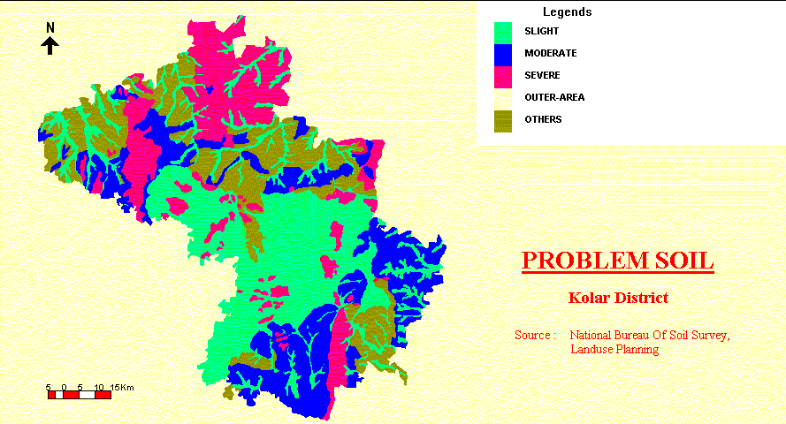
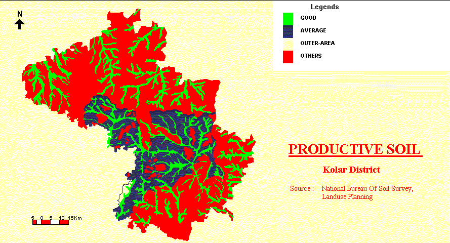
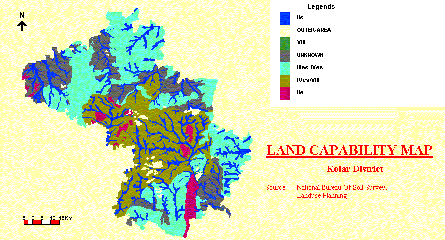
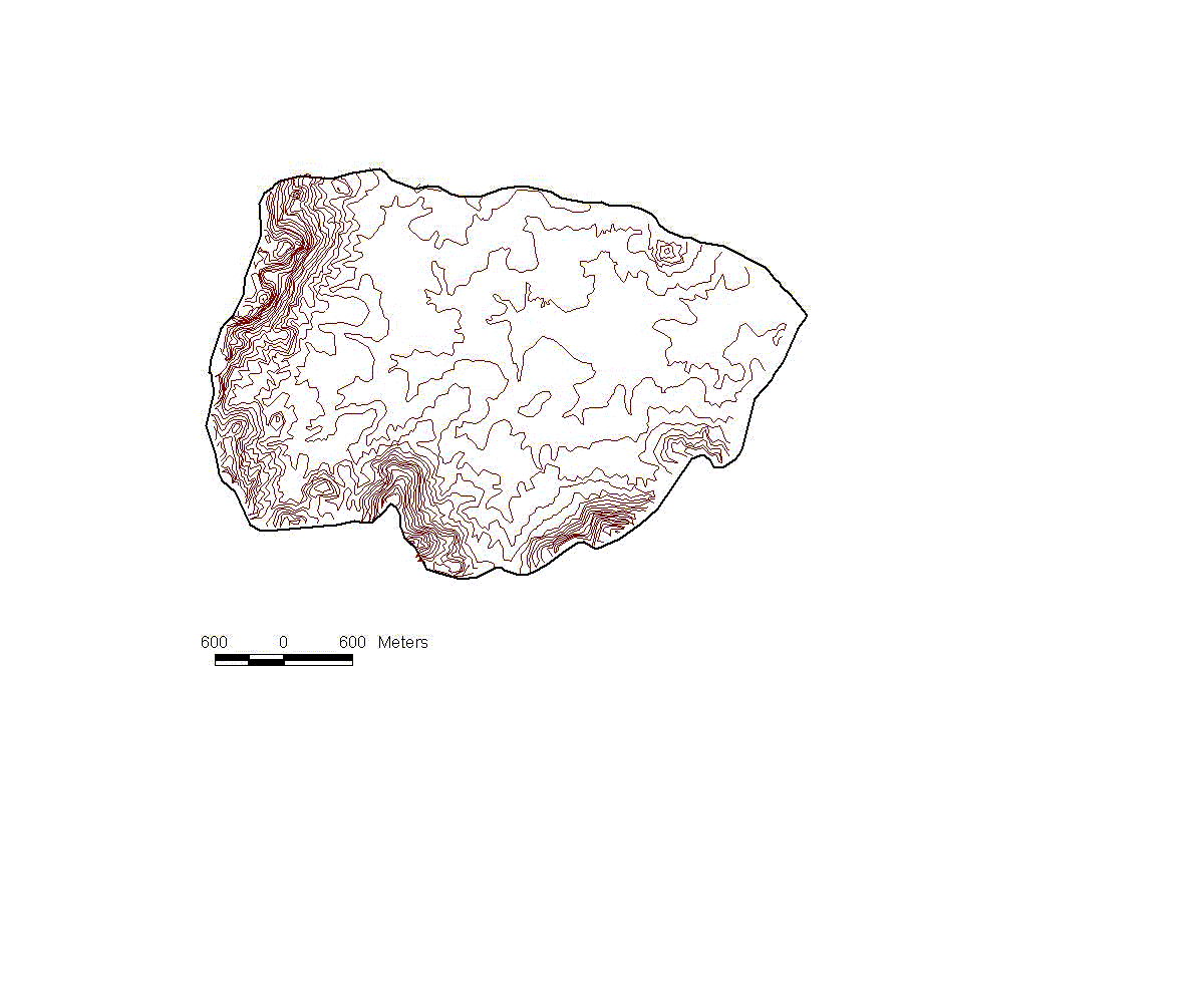
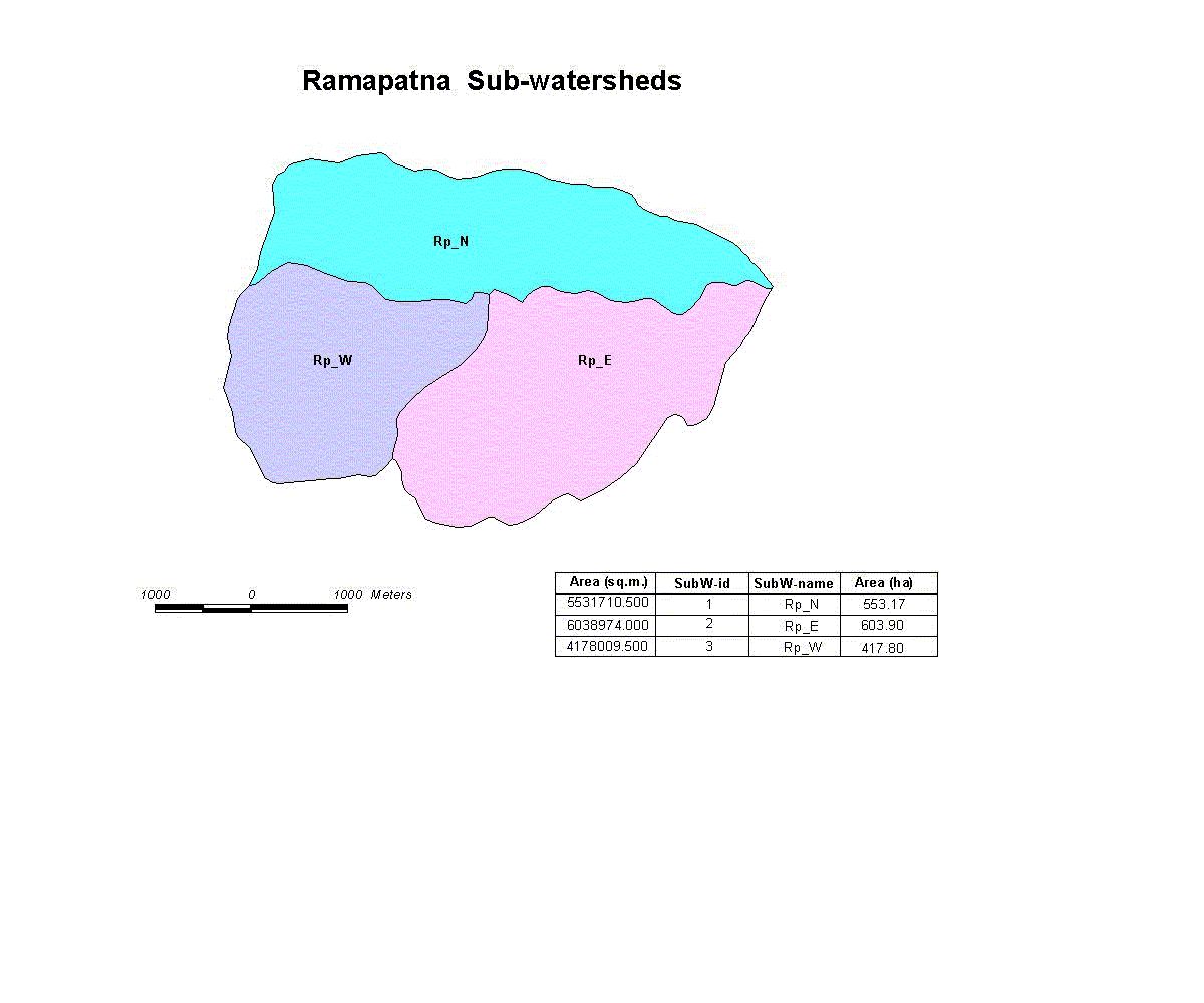
The data available for several of these fields are inadequate for many of the models that could otherwise be used to supply the information that decision-makers want. For instance, the soil erosion model, already discussed, demands details of rainfall intensity and duration, and soil erodability. Flood prediction, water resources and groundwater recharge models (being developed by collaborating institutions elsewhere within the NRDMS programme) depend upon data for infiltration rates, transmissivity and water storage in the soil and regolith. All of the more sophisticated procedures of land evaluation demand quantitative data for specific soil attributes such as soil depth, available water capacity, nutrient status, salinity, and depth to groundwater. These parameters are simply not available from the existing soil, geological and geomorphological maps of whatever scale. It is always possible to collect detailed data for specific attributes for special study areas, but this effort cannot be replicated. The problem of inadequate data is being handled in two ways: 3.3.3.2 Land use sustainability assessment (LUSA) To provide an immediate and useful service to decision makers, physical hazards have been identified: for instance drought, soil erosion, or excessive percolation under irrigation. Then, indicators of these hazards for which information can be obtained have been sought. These indicators, or limitations have been ranked in order of the ease of obtaining data; and the subtractive approach described by Shaxson (1981) has been applied. The procedure has been programmed to successively de-rate any parcel of land under consideration according to the severity of the limitations; arriving at a six-fold classification comparable to the well known land capability classification (Klingebeil and Montgomery 1961) but with additional loops to accommodate rice and irrigated land (Appendices I, II, III). The defining values for each class are locally calibrated and the result is expressed with up to three degrees of confidence, depending upon the completeness and quality of data used in the assessment, for example "not better than Class C – with one degree of confidence <C (1)" (Appendix IV). On the basis of the identification of hazards, district staff can design management packages to combat the threats to the sustainability of the desired land use, or recommend an alternative land use. In short, we are applying the threat identification and management concept outlined by Smith et al. (1999). 3.3.3.3 Transfer functions and models Transfer functions are being developed to derive the single attribute data required by LUSA and existing SDSS models: e.g. for the crop growth model - soil series > soil texture and thickness > available water capacity; for the groundwater model - lithological unit > permeability and fracture pattern > rate of groundwater recharge. For the usual case in which the existing mapping is not at the required scale, or shows only compound mapping units (e.g. soil associations), models are being developed to predict the attributes of interest from the 1:50 000 digital elevation model held within the GIS. This is done for each soil landscape which is identified as a pattern on the 1:50 000, satellite imagery by establishing the relationships between each attribute of interest and the position in the landscape and slope form. For the LUSA, even the 1:50 000 topographic base does not always permit the delineation of crucial slope differences, especially where the land is bunded. Once again the boundaries have to be inserted using interpretation of satellite imagery or air photos. 3.4 Test Area In order to test and validate the concepts of the SDSS, it is necessary to focus on a specific area of manageable size, for which reasonable data are available, and on specific decisions. Also, out of the set of possible decisions, we must select some specific decisions that are important both in the test area and elsewhere. In the first instance, (1) two talukas (blocks) were selected : Gudibanda and Chikballapur, for identifying the priority watersheds for NWDPRA scheme; (2) Ramapatna watershed (» 16km˛ = 1,600 ha), in Kolar District, for other applications of watershed characterization, identifying the priority sub-watersheds and sites selection for conservation/water-resources infrastructures (Figure 15). Ramapatna watershed was chosen for several reasons: (1) there are problems with land degradation, particularly gully erosion; (2) it has not been extensively treated by GOI programs; (3) new meteorological and stream gauging stations have been installed in Ramapatna within the past year, because the area is being modelled for water conservation by CWRDMS/Calicut; (4) the project team can communicate with local population in their own language; (5) data with typical scales and depth of information are available on various factors; (6) Bairasagara already falls under NWDPRA. Although the prototype SDSS is specific to the test area, the methodology is designed to be applied to any area of India with local calibration. 3.5 User Interface The DSS is proposed to present a simple, intuitive interface to the user, who is presumed to be somewhat a novice to the use of computers and certainly to GIS. An ideal interface is provided by ArcView: series of maps, complete with symbols and attributes, called themes, may be collected in views, each having a table of contents showing the themes. The user chooses which themes to view by marking a check box. Simple tools to zoom in and out, and to obtain information on map areas, are provided. User-level training in the ArcView interface can be completed in a half day. The DSS will be presented as a series of views: (1) input maps and tables; (2) derived maps; (3) ratings. These are collected in a single ArcView project, which in addition should have many tools disabled, e.g. the ability to add or delete themes or change the legend. These menus and buttons can be replaced with a customized interface that allows the end user to choose views. The Avenue manual (included with ArcView) explains how to do this. 3.6 Future development / Better service NRDMS centres are being set up in 27 districts in 10 Indian states, with complete coverage planned for Karnataka. The decision-support service that can be provided as of now meets the needs specified during the needs assessment. As far as land evaluation is concerned, it is unsophisticated but it is robust and functions with the data that are actually available in every district in India. With a better database we can provide a better service and a program to upgrade the database should begin with addition of the 10m contour data (which are already held by the Survey of India) to the digitized topographic sheets. Good use can also be made of the more recent, high definition satellite imagery. Both will improve our ability to describe key data both directly and through transfer functions. A cut-down version of the Automated Land Evaluation Systems (ALES) can be bolted on to the SDSS to provide land suitability evaluation for specific crops and land use types; including basis financial/economic analysis. Fieldwork in Kolar District has identified falling water tables as a major concern. This is attributed to extraction of water by tube well for irrigation. It is desirable to prepare catchment maps of present land use and LUSA, and water budgets for each land use types, paying special attention to the apparent mismatch of flooded rice cultivation and soils of high permeability. Groundwater of low salinity is being pumped from the fissured granite aquifer, which has been severely depleted. This water is being applied to irrigated crops and salinity is now apparent in the shallow water table and the fields. Evidently, the shallow groundwater is not, or only weakly connected with, the deeper, presumably confined aquifer. The SDSS will give useful spatial information on these emerging threats and highlight the areas of inefficient water usage. 3.7 (Logical) Database Design Database design forms a systematic description of the data and their relationships that could form the basis of the development of a GIS. A few project team members have undergone training on ‘GIS Design : Planning and Implementation’ for 10 days in May 1998 at KSCST-Bangalore along with the other NRDMS groups (Main Instructor : Prof H.W. Calkins, NCGIA, Buffalo). Database design has been carried out and documented for each application. This work involves the following requirement analysis, and used the methodology described by Prof. Calkins:
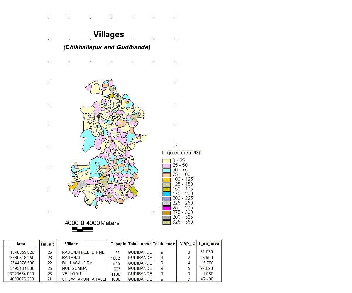
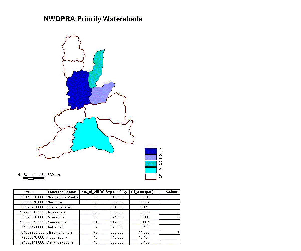
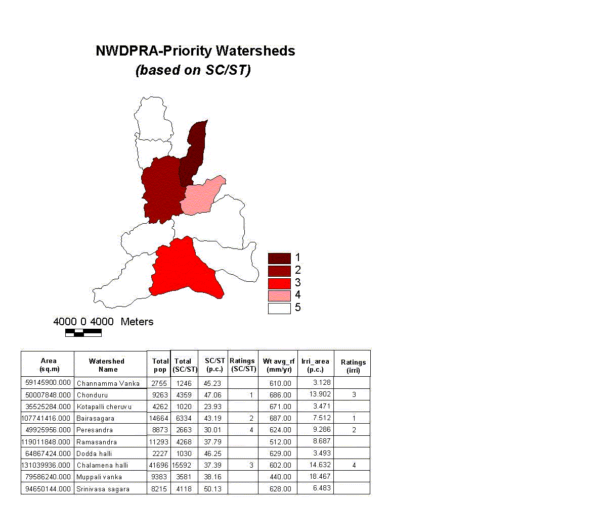
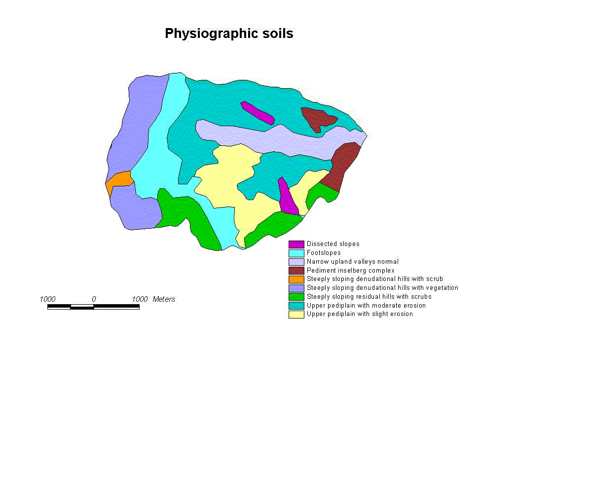
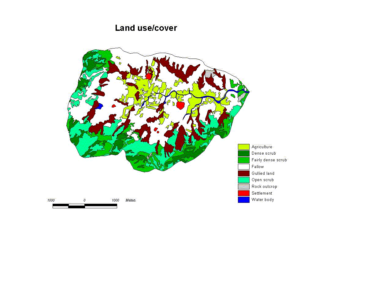
ER technique is a graphical method of representing the objects (entities) of a database, relationship between the entities and the attributes of entity and relationship that should be captured in a database. Database design for NWDPRA Watershed selection, as an example, is depicted in Appendix V. 3.8 Module Description This approach helps one to describe the development of a module for any application / DSS, and explains the following :
Module description has been worked out and documented for each of the application. In the SDSS/LUP model for conservation management aspects, the following models/criteria have been used for different applications :
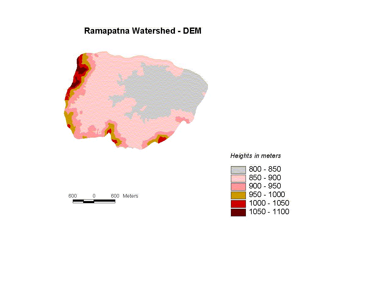
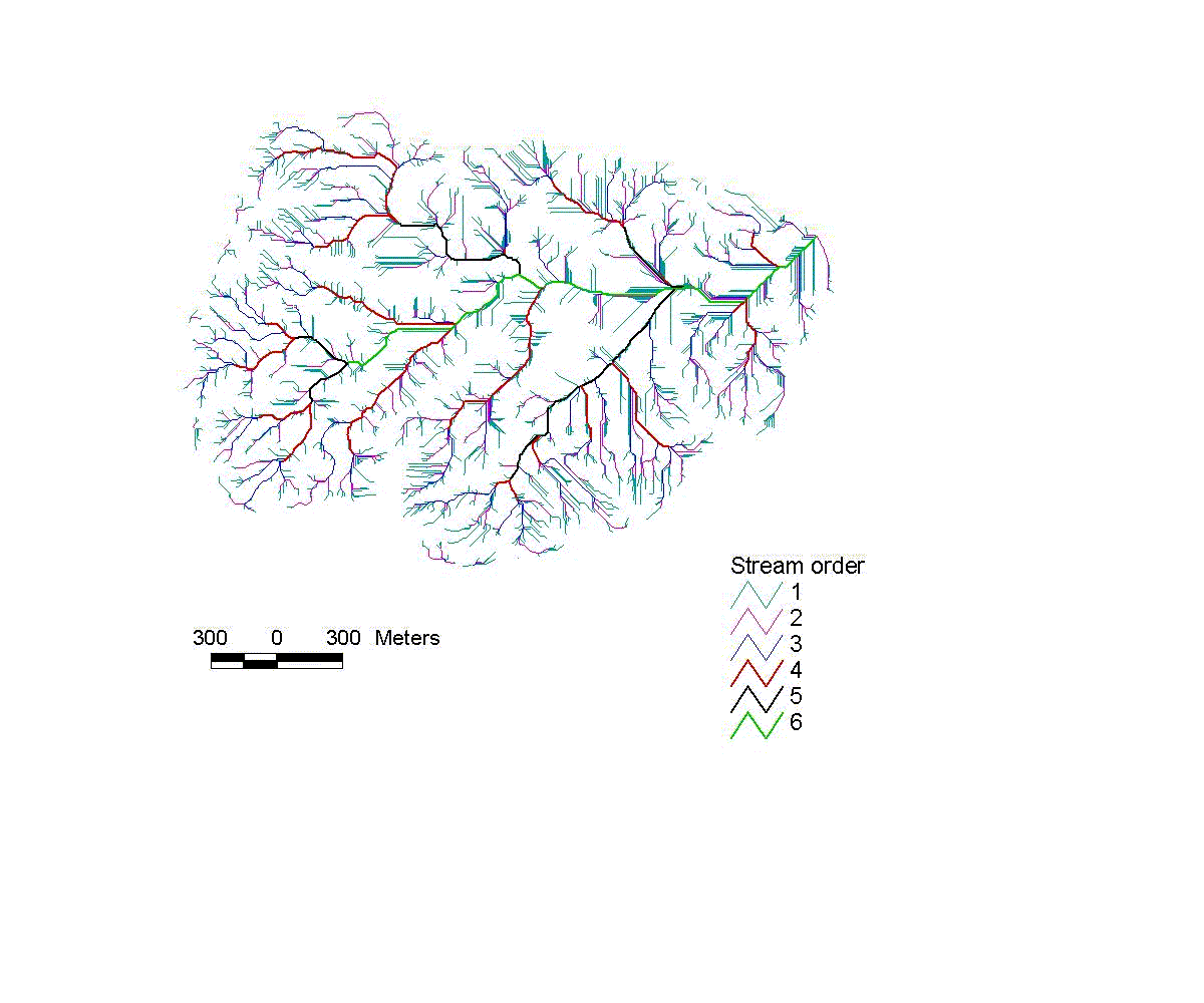
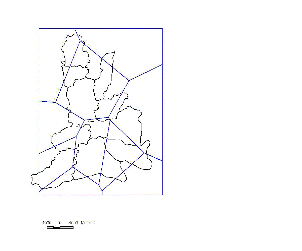
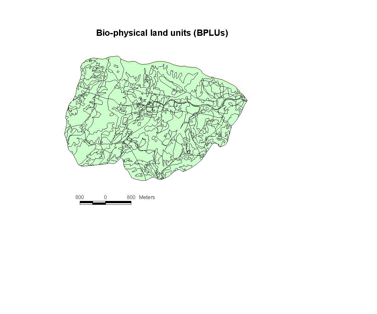
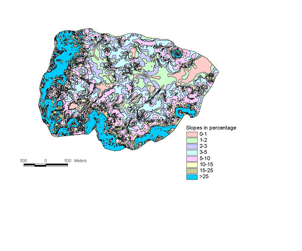
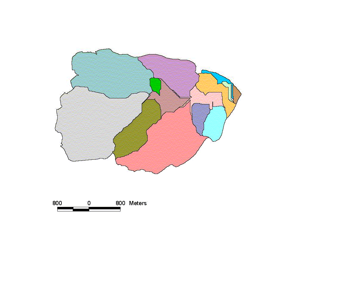
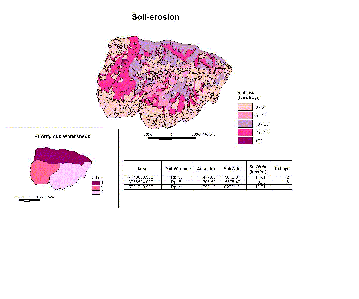
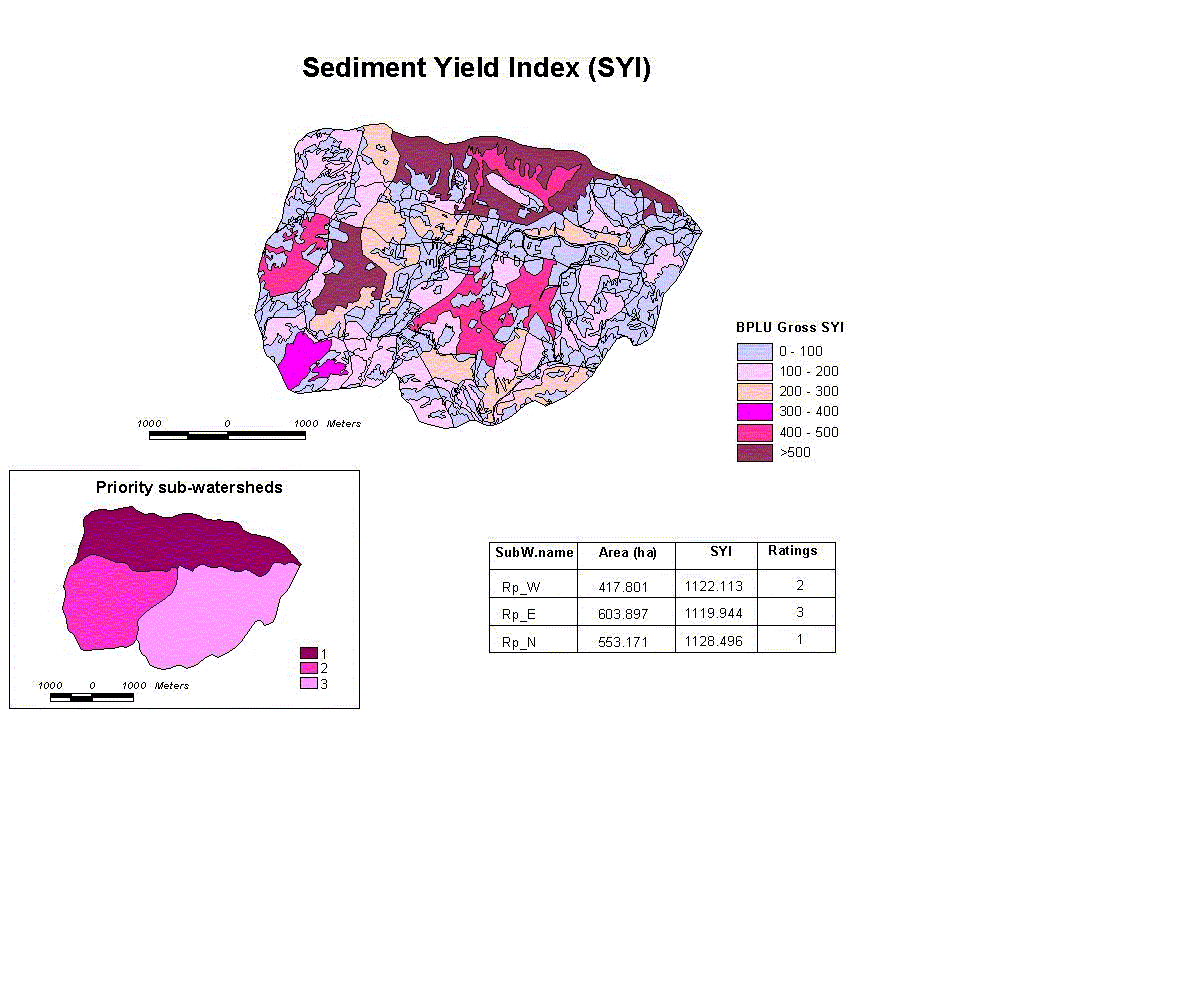
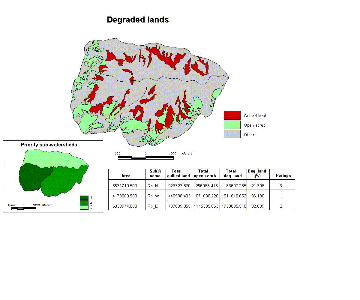
Initially, The SDSS/LUP concepts were tested on conservation planning aspects of watershed characterization (drainage and its stream order; slope and watershed delineation); selecting the priority watersheds/sub-watersheds; and identifying the suitable sites for infrastructures (check-dams and percolation tanks). A prototype modeling and their preliminary results on various applications / scenarios for prescriptive planning was examined and presented below briefly. 3.9.1 Prototype model Automated watershed characterisation, which includes determination of drainage network, stream order, slope and watershed delineation was carried out by using the GRID module of ARC/INFO. Contours (Figure 16) and watershed boundary maps, generated from the SOI topographic sheet of 1:25,000 scale, were scanned and vectorized and converted to ARC/INFO coverages. These were edited and geo-referenced. TOPOGRID is a surface interpolator that is highly optimised to produce a hydrologically correct surface. The TOPOGRID command interpolated the surface using all elevation inputs generating the DEM coverage and then clipped the DEM (Figure 17) to the watershed boundary coverage. This helped to ensure creation of a good surface along the edge of the watershed. Flow accumulation grid was generated by the FLOWACCUMULATION function, which computes the amount of water that flows into each cell from all of the uphill cells. This was used to identify the drainage courses by extracting those cells with the highest accumulated flow. Experiment with various accumulation values to extract drainage networks with different levels of detail was performed to obtain a close match to the SOI natural drainage system. The final drainage network of desired detail was created by choosing the appropriate number of cells (volume values) and converted into coverage. GRID module was used to assign Stream Order values and/or unique ID’s to the drainage network. FLOW DIRECTION determines the direction in which the water flows out of a cell, by comparing the elevations of the neighbouring cells. STREAMORDER function was used to assign STRAHLER order codes to drainage network. It used both the DRAINAGE NETWORK grid and the FLOW DIRECTION grid to assign the stream order codes (Figure 18). Small and undesirable first order streams were eliminated with the help of Map Algebra. For Watershed Delineation, SNAPPOUR function in GRID module was used to select the pourpoints in the flow accumulation grid. The WATERSHED function created a grid of the watershed area above the pourpoint from the outputs of SNAPPOUR and FLOWDIRECTION functions. LATTICEPOLY function in GRID module was used to generate the Slope of the watershed. The surface created by TOPOGRID was the input for LATTICEPOLY function. The slope map automatically generates a default look up table with 8 divisions of slope classes. However, the slope map of any desired ranges can also be generated by creating a fresh look up table. NWDPRA criteria were used to identify the sites for priority watersheds in two under-developed talukas in Kolar district. Mylar bases were generated for the purpose include taluka boundary (1) for Chikballapur and Gudibanda talukas; watersheds (2) of 50-100 km2 and rain gauge stations (3) in and around the above talukas. Mylar bases were prepared from SOI topographic sheets of 1:50,000 scale. The village map of the talukas along with the attribute data (containing the details of socio-economic and other physical data, including the irrigated area) was converted into ARC/INFO coverage from MAPINFO files supplied by the KSCST-Bangalore. The mylar bases were scanned, vectorized, transformed to ARC/INFO coverages and finally edited and geo-referenced. The rain-gauge station map was used to generate Thiessen polygon in EditTools by using THIESSEN function under Proximity Analysis (Figure 19). Proportionate irrigated area of each watershed was calculated from the village-irrigated area (Figure 20). Finally, the watersheds were prioritized based on NWDPRA criteria (Figure 21). Prioritization of NWDPRA watersheds was also carried out using the SC/ST population in the watersheds (Figure 22), in addition to the physical factors. Prototype modelling also includes generation of different scenarios for sub-watershed prioritization in Ramapatna watershed. This is mainly to identify the priority sites for different schemes based on different physical factors : (1) on-site effects (soil erosion intensity), including identifying the hot-spots for interventions (Morgan’s model); (2) off-site/down-stream effects (sedimentation) and its critical sectors (AISLUS Sediment Yield Index model); (3) extent of degraded lands from remotely-sensed data for reclamation. Multi-source thematic maps of physiographic-soil (1:50000 scale map from KSRSUC, Bangalore prepared for IMSD project) (Figure 23), landuse/cover (IRS-1C PAN remote sensing data at 1:125000 scale) (Figure 24) and sub-watersheds of 500-650 ha (1:25000 SOI topomap) (Figure 25)were generated and were converted into ARC/INFO coverages after scanning and vectorization. They were edited, geo-referenced, overlayed to generate Bio-Physical Land Unit (BPLU) map (Figure 26). These BPLUs combinations (Appendix VI) were considered as strategic natural units for sub-watershed prioritization. Parameters were derived as per the requirement of Morgan’s model and soil loss was calculated in t/ha for each BPLU. Ranges (zones) were determined to indicate low, moderate, severe and very severe erosion intensities. These severe zones are the critical sectors (hot spots) for interventions. Finally, the erosion values of all the BPLU’s in each sub-watershed were aggregated and prioritized based on the total soil loss. Similarly, the gross sediment yield index values of each BPLU was calculated using AISLUS’s SYI model and assigned the ranges to know about hot-spots in the watershed. SYI values of each sub-watershed were calculated and rated the sub-watershed to indicate the priority sites for preferential treatments. Degraded culturable lands of gullied and open-scrub, were extracted from remote sensing-based land use map. By overlaying the sub-watershed map in ARC/INFO, areal extent of these wastelands (in per cent) was calculated for each of the sub-watershed. Sub-watersheds were then prioritized on the basis of extent of wastelands for reclamation schemes. The IMSD criteria were used to identify the sites for percolation tanks (water resources infrastructure) and check-dams (small-scale conservation infrastructure) in Ramapatna watershed. The location of percolation tanks depends on the slope, soil permeability, good fracture development and in the micro-watersheds of 25-50 ha size. System-generated slope and micro-watershed maps were used to select the areas of less than 2.15 % slope and watersheds of 25-50 ha. Soil units from the soil map were merged based on soil permeability classes and extracted the moderate soil permeability class for the purpose. Lineament map was generated from IRS PAN data, and converted as ARC/INFO coverage after performing the standard procedure. Buffering of one-third size of the each of the lineament was done by using BUFFER command in ArcEdit. The area inside the buffer zone was considered as the suitable site. All the above derived maps were overlayed and the suitable zones for constructing the percolation tanks were identified in the watershed. DSS on site selection for check-dams in the watershed to be built or authorized by the Government is in progress. In general, check-dams are constructed on lower order streams with medium slopes. They are proposed where water-table fluctuation is very high and the stream is influent / intermittently effluent. The catchment areas vary widely, but an average area of about 25 ha should be there. The parameters to be considered are slope, soil cover and its thickness and hydrogeological conditions of rock type, thickness of weathered strata, fracture, depth to the bedrock. There should be some irrigation wells in the down-stream of the proposed structure. 3.9.2 Preliminary results
Table 3. Scenarios / Multi-criteria evaluation
The user departments involved in various watershed/conservation management programmes can choose the above sites of watersheds/sub-watersheds on priority basis depending up on the above physical/socio-economic problems.
AISLUS (1991). Methodology of priority delineation survey. All India Soil and Land Use Survey, Department of Agriculture & Co-operation, Ministry of Agriculture, Government of India. New Delhi. Dent D .L. and A. Young 1981 Soil survey and land evaluation. George Allen and Unwin, London. FAO 1976 Framework for land evaluation. Soils Bull. 32, Rome. FAO 1985 Guidelines: land evaluation for irrigated agriculture. Soils Bull. 55,Rome. IMSD (1995). Integrated Mission for Sustainable Development, Technical Guidelines. National Remote Sensing Agency, Department of Space, Government of India, Hyderabad. Janssen, R. and M. van Herwijnen 1992 DEFINITE: Decisions on a finite set of alternatives. Kluwer Academic Publishers, Dordrecht. Klingebiel A.A. and P.H. Montgomery 1961 Land capability classification. U S Dept Ag. Hbk 210, Washington DC. Morgan, R. P. C., D. D. V. Morgan, & Finney, H.J. (1984). A predictive model for the assessment of soil erosion risk. Journal of Agricultural Engineering Research 30: 245-253. Reprinted as pp.251-259 in: Morgan, R. P. C. (ed.) Soil erosion and its control. New York, Van Nostrand Reinhold. Morgan, R.P.C., Hatch, T and Wan Suleiman, Wan Harun. (1982). A simple procedure for assessing soil erosion risk; a case study for Malaysia. Zeitschrift fur Geomorphologie N.F. Suppl-Bd. 44: 69-89. NBSS & LUP 1989 Agro-ecological zones of India ICIAR, Delhi. National Land Use & Conservation Board 1991 National consultation on perspective plan for conservation, management and development of land resources of the country, October 21-24, New Delhi. Discussion Paper. Min. of Agriculture, Dep. of Agriculture & Cooperation, New Delhi. Rossiter D.G. and A. van Wambeke 1997 ALES Version 4, Users’ Manual. SCAC Teaching Series T93-2. Soil, Crop and Atmospheric Sciences Dept, Cornell Univ., Ithaca NY. Shaxson, T.F. 1981 Determining erosion hazard and land use incapability: a rapid subtractive method. Soil Survey and Land Evaluation 1,3, 44-50. Smith C., R. Thwaites and G. McDonald 1999 TIM : evaluating the sustainability of agricultural land management at the planning stage. The Land 3,1, 21-38. Venkatachalam P., B.K. Mohan and S. Shekhar 1998 GRAM++ Design Document (version 2.0). UNDP (GIS based Technologies for Local Level Development Planning ) / DST, Govt. of India (Development of GRAM for Windows), CSRE, IIT-Bombay. Wischmeier, W. H. and D. D. Smith (1978). Predicting rainfall erosion losses - a guide to conservation planning. Washington, DC, US Government Printing Office.
|
||||||||||||||||||||||||||||||||||||||
Quick
Links :
|
||||||||||||||||||||||||||||||||||||||